Good morning Hurricane Watchers! 🙂 Ernesto is looking less and less like a problem for most of Atlantic Canada.
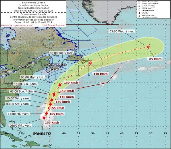
➡️ The current track, which will change, now has Ernesto as a Category 1 hurricane as it enters Canadian waters.
➡️ Ernesto is forecasted to weaken significantly as it approaches Newfoundland (150kph early Monday nearing Canadian waters to 110kph early Tuesday just east of St. John’s)
➡️ Ernesto may make landfall in eastern Newfoundland on Tuesday as a strong post-tropical depression.
⚠️ It remains prudent to monitor this storm especially as the weekend comes to a close.
From NOAA Forecasting and Advisories…
At 500 AM AST (0900 UTC), the center of Hurricane Ernesto was located near latitude 28.1 North, longitude 67.0 West. Ernesto is moving toward the north-northeast near 13 mph (20 km/h). This general motion is expected to continue today followed by a slower north-northeastward motion on Saturday. A faster northeastward motion is expected late in the weekend. On the forecast track, the center of Ernesto is expected to pass near or over Bermuda on Saturday.
Maximum sustained winds remain near 100 mph (155 km/h) with higher gusts. Some strengthening is forecast during the next day or so, and Ernesto is forecast to be a large hurricane near Bermuda on Saturday and maintain hurricane strength through the weekend.
Ernesto is a large tropical cyclone. Hurricane-force winds extend outward up to 70 miles (110 km) from the center and tropical-storm-force winds extend outward up to 265 miles (425 km).
The estimated minimum central pressure is 968 mb (28.59 inches).